Alum Talk on Disaster Preparedness
Architect and landscape architect Miho Mazereeuw ’96 has spent three decades researching how communities can proactively plan and prepare to rebuild vibrant cities after a disaster occurs, reducing their vulnerability and risk in a rapidly urbanizing world.
In January 1995, when Mazereeuw was a junior at Wesleyan double majoring in Art Studio and Earth and Environmental Sciences, an earthquake struck Kobe, Japan, where her parents were living. “My father’s workplace was destroyed,” said Mazereeuw, associate professor of Architecture and Urbanism and director of the Urban Risk Lab at Massachusetts Institute of Technology (MIT). “It started my exploration of trying to understand our built fabric, and how we can design and plan better for these kinds of events.”
During a talk on February 18, Mazereeuw shared case studies of Japan’s Bosai (disaster prevention) culture, including examples of large-scale urban systems, park networks, and architectural projects, in the Reading Room of the Ezra and Cecile Zilkha Gallery following an afternoon workshop with design students in the College of Design and Engineering Studies (CoDES) program.
Mazereeuw spoke about the MIT Urban Risk Lab’s focus on what she called “action research,” working with communities and local governments to develop methods and technologies to embed preparedness into the design of cities. Her team looks into what challenges might exist in response and recovery processes, finding gaps between national, state, and municipal policies in the United States.
“Why are we deciding on such important issues when lives are lost, and everything is chaos?” Mazereeuw asked. “Why can’t we start to think about these things beforehand?”
Mazereeuw described the Urban Risk Lab’s Housing Recovery Toolkit, which brings together disaster managers, housing and planning departments, and community organizations before anything goes wrong in order to plan to rebuild an ideal city. “A lot of places don’t have time to plan or prepare for these things, or really to commit the time,” Mazereeuw said. “Local governments can use this at their pace whenever they have time, and because it’s an online tool, they’re able to update it when necessary.”
Following the Great Kantō earthquake in Tokyo in 1923, when over 105,000 people were killed by building collapse and fires, Mazereeuw said the recovery process included strategies of creating firebreaks—or barriers such as rivers or wider roads—and the use of fire-resistant building materials throughout the capital city to slow or stop the progress of future fires. “There’s a number of incentives and different programs within these communities to start to become more and more fire resilient,” Mazereeuw said.
Mazereeuw said evacuation parks can be used in multiple ways during different phases of a disaster, including training drills, evacuation, emergency sheltering and tents, recovery education, and temporary housing. She said parks should be designed to have water elements, topography to block winds, and different kinds of less flammable trees in order to best protect people.
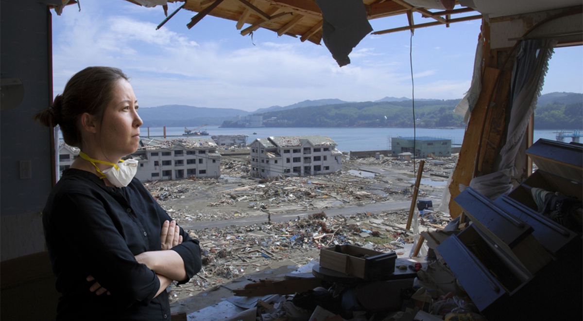
Mazereeuw highlighted several of the more than 50 dual-use Japanese parks she has visited with her team, including a Hyogo stadium that stores supplies including blankets, diapers, tarps, rice, and toilets, and also transforms into a distribution area during a disaster. An Osaka park includes similar embedded infrastructure, including a barbecue area to purchase or cook food on benches that can transform into grills in an emergency, and bathroom facilities that can triple in size by setting up outdoor tents. After the 2011 Tōhoku earthquake and tsunami, Mazereeuw said the rebuilding efforts of Japan’s national government in some places took more than a decade, and included relocating people to higher ground, building seawalls that could be as tall as 45 feet, and either raising the coastal land or taking down parts of the mountains so that they could use the land.
Mazereeuw said Japan is preparing for an expected tsunami in the southern Nankai Trough region sometime in the next 30 years, when residents in some towns can expect a series of waves over 110 feet tall with only a 15-minute warning to evacuate. “It’s hard to figure out exactly when that would happen, but the region is really preparing for it by designing several different kinds of tsunami evacuation towers,” Mazereeuw said.
Mazereeuw’s book Design Before Disaster: Japan’s Culture of Preparedness will be published by University of Virginia Press in June, offering a holistic framework to design for anticipated disasters.