Scientists, Students Get to the Core of Block Island
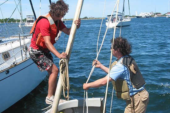 |
| Conor Veeneman ’09 and Joel LaBella, facilities manager for the Earth and Environmental Sciences Department, prepare to take a core sample of Block Island’s Great Salt Pond. Sediment samples may reveal that Block Island was not formed by the conjunction of two smaller islands more than 6,000 years ago, which is the current belief. |
| Posted 08/06/08 |
| More than 2,500 years ago, Native Americans settled on an area of land located about 13 miles off the coast of Rhode Island. They named the area little island or little god place. Much later, in 1614, it was charted by Dutch navigator Adrian Block and became known by colonists as the name it retains today: Block Island.
Now a popular tourist destination, the island is full of geological mysteries. But a group of Wesleyan-affiliated researchers have spent the summer studying the geologic and environmental history of the island. They are particularly interested in the environmental impact of humans, tracing a time line from the early Native Americans inhabitants to colonial settlers to present day.
The island research team includes Varekamp; his wife Ellen Thomas, who is a research professor of earth and environmental science at Wesleyan and a senior research scientist at the Center for the Study of Global Change at Yale University, as well as students from Wesleyan, Macalester College, Bryn Mawr College, Smith College, and The State University of New York at New Paltz. The study and student participation was made possible by a grant from the W.M. Keck Foundation A majority of their fieldwork was conducted in various water basins on the island, most prominently the massive Great Salt Pond. In July, the group used 40-foot-long aluminum pipes to core or extract layers of sediment from three locations. Nowadays, the Great Salt Pond is true to its name. Its currently salty water, a close concoction of regular seawater. But during humans colonization of the island, the pond went through bouts of being a fresh water basin. The initial core records suggest that most of the time the Great Salt Pond was indeed salty, so with this study, we hope to reconstruct these periods of fresh or brackish water versus the open periods with salt water, Varekamp says. The pond was totally closed off from the sea for some time; the story is that the Native Americans opened a connection with the sea, but that rapidly filled-in with sand. Once the colonials arrived around 1661, they opened it up again. If the spot is not dredged regularly, it will fill in with sand. The core samples also reveal eutrophication or increase in chemical nutrients in the ponds ecosystem. By examining the sediment, Varekamp notices significant color changes to the marine soils. Sediments dating to early in the last century are gray to olive-gray, which shows a natural process in the pond. The sediment at top of the core samples, which are from more recent times, are solid black indicating a dramatic, human-influenced change to the ponds ecosystem during the last 100 years or so. The three Wesleyan students, Sarah Gillig 09, Conor Veeneman 09 and Emma Kravet 09, assisted with multiple aspects of the study such as collecting foraminifera data (saline versus fresh waters, enclosed basin versus open marine bay), mercury analyses, and selecting shells for radiocarbon dating. Gillig, a Hughes Fellow, analyzed foraminifera in attempts to examine the popular idea that Block Island was formed by the conjunction of two smaller islands more than 6,000 years ago. We have not found any evidence for that in our cores yet, but it will be another two months before we have our radiocarbon dates back from the lab with ages, Varekamp says. The problem is, our cores may not go back 6,000 years! The group received help from local residents, including Walter Filkins III 70, who allowed the team to use his boat. Our research team was fun and motivated, but thanks to the locals, our time on the island was efficient, successful, and relatively painless, says earth and environmental sciences major Veeneman. The consistent and overwhelming support of the local islanders lending boats and supplies, providing helpful insight of the island culture and history was indispensable to our sample collection and overall research progress. Varekamp, who specializes in mercury studies, also cored the islands water basins for any signs of pollution. Because Block Island is a remote environment, any mercury found on the island is deposited from the air and originated elsewhere. In a previous study, he found that there was about fifty percent less mercury pollution on the island than found in central and eastern Connecticut. The researchers are currently finishing basic sample processing at Wesleyan. In late August, they will send their samples of interest to external labs to determine mercury levels, carbon/nitrogen ratios, radiocarbon dates and foraminifera species concentrations. They will present their data and an island evolution model during the North Eastern Estuarine Research Society on Block Island in October. Their research was featured in the Block Island Times July 14. |
| By Olivia Drake, The Wesleyan Connection editor. Photos contributed by Joop Varekamp. |
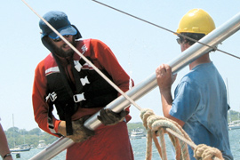 Our long term goal is to investigate the history of the island back to the time of the last ice age approximately 20,000 years ago when the glaciers retreated from the island, explains Johan Varekamp, the Harold T. Stearns Professor of Earth Science (pictured in orange at left). When did large lakes form there? Which drained and when did the sea inundated the former land with the modern island as its remnant? What associated changes in land use cutting of forest, beginning of agriculture, first with corn and cattle led to extensive deforestation? There are many questions to be answered.