Students Use GIS Skills to Help Solve Environmental Problems

Fifteen Wesleyan students who were enrolled in the Introduction to GIS course this fall learned how to apply GIS concepts and skills to solve local problems in environmental sciences.
Kim Diver, associate professor of the practice of environmental sciences, taught the class and an accompanying service-learning lab component. After learning about the basic theory of Geographical Information Systems (GIS), data collection, data management, spatial analysis, visualization, and map preparation, the students were paired with a community partner or organization to assist them with an issue.
On Dec. 5, the students presented the results of their projects to their community partners and other students and faculty.
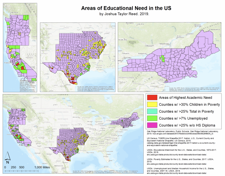
Joshua Reed ’21 worked with Wesleyan Book Buds, an Office of Community Service student group on a study titled “The Relationship Between Education and Poverty in the US.”
Reed, a computer science major and Wesleyan Questbridge Scholar, grew up in a poor community in rural Oklahoma and wanted to explore the difference between urban and rural poverty.

By using data from the USDA, US Census, and the Oak Ridge National Laboratory, Reed discovered that the West Coast faced a surprisingly large amount of unemployment but minimal poverty levels; the southern section of the Midwest had rampant poverty, especially involving children; and the Northeast, with the exception of areas around New York City, had very little poverty of any kind. Nationwide, areas in southern Texas had the highest academic need.
Cole Reistrup ’21, Andrew Hennessy ’21, and Aashni Parikh ’22 collaborated on a study titled “The West Virginia Water Project” with the Blue Ridge Watershed Coalition (BRWC), a community-based watershed group. The BRWC has taken near-monthly samples of more than 15 sites along the Shenandoah River and its tributaries in Jefferson County, W.Va. from 2013–present. All samples were sent to the Friends of the Shenandoah River laboratory for water quality testing via 10 parameters (nitrates, E. coli, pH, conductivity, etc.).
The group used specialized GIS software—ArcMap and ArcCatalog—to visually display data about land use, water samples, sources of pollution, and potential receptors. They also used a program called R to create figures from BRWC water sample data and visualize trends in parameters.
“Our goals were to present the results of data analyses, identify and discuss sources of pollution, suggest what can be done to improve conditions, and express why protecting the Shenandoah River is critically important,” Reistrup said. “We hope that our report may be used to educate others on water quality and pollution issues and that our ArcMap files may serve as the foundation for further exploration, analysis, and record-keeping by the Blue Ridge Watershed Coalition.”
Other projects included:
Katie Toner ’20, Miles Brooks ’20, and Andy Tan ’21 collaborated on a project titled “Geographic Pattern of Invasive Water Chestnut in the Connecticut River Watershed.” They worked in collaboration with the Connecticut River Conservancy.
Emily Litz ’20, Annie Afranie ’20, Kush Puri ’21, Marlen Escobedo ’21, and Caroline Seibold ’20 worked on a project titled “Incidence of Tick-borne Disease over Time and Space in Relation to Climatic Factors.” They partnered with the Connecticut Agricultural Experiment Station.
Justin McIntosh ’21, Claire Taub ’20, Delaney Wood ’20, and Gavin Willis ’21 partnered with the Middletown Police Department for a study titled “Spatial Analysis of Car Thefts in Middletown.”
And Timothy Yen ’21 worked with the Connecticut Department of Energy and Environmental Protection on a project titled “The Spread of the Invasive Asian Clam in Connecticut Streams.”