Study May Affect Future Land Use in Middlesex County
 |
|
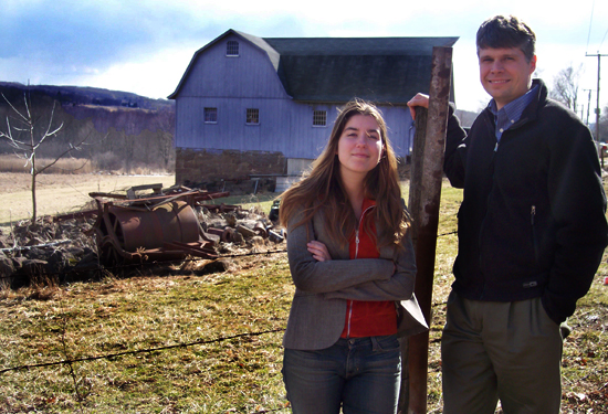
| Jessica Pfund, ’05 and Phillip Resor, assistant professor of earth and environmental sciences, observe one of Middletown’s few remaining agricultural sites. | |
| Posted 02/23/05 | |
|
It started out with little more than an idea, some old aerial photos and a handmade map. Several months and a lot of hard work by three dedicated people later the result may provide a whole new way to evaluate and influence the look and growth of towns in Middlesex County for years to come. Not bad considering it all started out as a question from an inquisitive undergraduate. The undergraduate, earth and environmental sciences major Jessica T. Pfund `05, was a student Earth and Environmental Science 322: Introduction to GIS (Geographical Information Systems), in the spring of 2004. The classs instructor, Phillip Resor, assistant professor of earth and environmental sciences, had brought in a guest speaker, Sandy Prisloe, a geospatial extension specialist from the University of Connecticuts Center for Land-use Education and Research (CLEAR). Prisloes presentation included a discussion of how satellite data were being used to quantitatively measure changes in Connecticuts landscape and to infer the impacts of these changes on the quality of life and the environment. Sandy mentioned that he had a map from the 1970s that showed the areas that were farmland at that time, says Resor. He also mentioned that, if someone was motivated to use data that was recently created by a the group at the University of Connecticut showing the land cover in 2002 and compare what was found to the data from 1970, it would be interesting to see how things had changed. Pfund was intrigued, and she was looking for a possible research project. Many of my classmates were doing studies that were more theoretical and scientific, she says. This seemed to have scientific and social implications for the local area that could have a relatively immediate impact. After discussing the idea further with Resor, Pfund decided: this would be her project. Aided by a $2,500 grant from the Middlesex County Community Foundation and additional support from the Mellon Foundation and The University of Connecticut, Jessica, who was responsible for the bulk of the data collection, got to work. I dont think when I started I had an idea of exactly what I was getting into, Pfund says, now almost a year into the project. Its been very interesting and exciting, but its also been a lot of work. Much of this was linked to the differences in how the information being examined was generated. The images from the 1970 study were based on a hand-made mylar map that was in turn based on aerial photographs of the county. The information this would be contracted with was generated by images derived from satellite images of the same area in 2002. The images and data didnt match up, says Resor. The satellite images are way precisely located, but cant image anything smaller than 30 meters. By contrast, the 1970s map was generated by aerial photographs and on the ground surveys that could capture small details, but werent necessarily as well located. So we had to find ways to account for the differences. There were some other challenges too. For instance, the old maps identified the land as: active agricultural, inactive agricultural or nonagricultural. GIS images provided more than a dozen different characterizations, including assessments of soil viability for agricultural use and disposition of wetlands. Translating the GIS data also had some interpretive challenges that were produced because of how things have been done in the state over the years. Because of the way small plots of land are often used in Connecticut, what LandSat (the satellite) may identify as a large lawn area may actually be an active or inactive cultivated field, Pfund says. This meant we had to visit some locations in person to verify exactly what the use was. Currently there is still a substantial amount of data to crunch and quantify, but Resor and Pfund anticipate having the study done sometime in the spring. They will publish a report with Prisloe detailing their findings. There will be public presentations and discussions of the data at town meetings in Middlesex County. The towns can then use the data to better plan new housing and business construction. A lot of towns in Middlesex County are proud of their rural atmosphere, Resor says. This information can help them maintain that atmosphere as they move forward with new developments. However, the study has already generated a result that will be producing more benefits for the county. Resor received a service-learning grant from Wesleyan to expand his efforts in these types of studies. This spring, his students are working on similar projects for The Nature Conservancy, The Connecticut River Costal Conservation Commission, The Middlesex Land Trust and the Town of Portland. Its been pretty interesting to do a scientific study that actually has social implications and affects local issues, says Pfund. People dont often think of scientists working that way. Its been a very rewarding project. |
|
|