COVIDmap-760x517.jpg
Olivia DrakeMay 11, 20202min
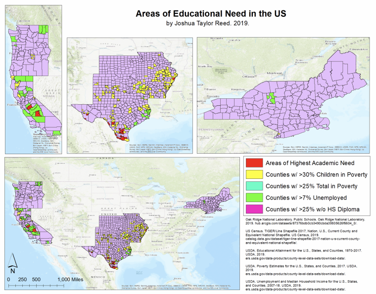
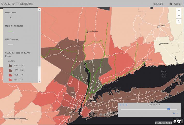
In late March, as New York City's coronavirus infection rate skyrocketed to five times higher than the rest of the country, members of Wesleyan's Traveler's Lab explored a movement-focused approach to the rapid spread of the disease. Rather than focusing on political borders, lab members depicted major freeways, highways, and commuter rail lines out of New York City, and examined counties within a 2.5-hour drive from the City. "While New York City may be the center, it is the travel region immediately surrounding the city that provides the true context of how COVID-19 has spread and is spreading to, and…

joshuareed-760x595.png
Olivia DrakeDecember 17, 20192min
Fifteen Wesleyan students who were enrolled in the Introduction to GIS course this fall learned how to apply GIS concepts and skills to solve local problems in environmental sciences. Kim Diver, associate professor of the practice of environmental sciences, taught the class and an accompanying service-learning lab component. After learning about the basic theory of Geographical Information Systems (GIS), data collection, data management, spatial analysis, visualization, and map preparation, the students were paired with a community partner or organization to assist them with an issue. On Dec. 5, the students presented the results of their projects to their community partners…

stu_GIS_11142018012-copy-760x548.jpg
Olivia DrakeNovember 19, 20182min
On Nov. 14, Wesleyan celebrated geography, mapping, and spatial data analysis at the annual GIS Day. GIS Day provides an international forum for users of geographic information systems (GIS) technology to demonstrate real-world applications that are making a difference in our society. The first formal GIS Day took place in 1999. During GIS Day, the Wesleyan community was invited to participate in multiple activities, including a hands-on humanitarian map-a-thon, a seminar on digital storytelling with maps led by Sam Raby '17, and games involving "Fun with GIS." The events were led by students taking the E&ES 281: GIS Service Learning course…

Jackie-2-760x457.jpg
Olivia DrakeJanuary 22, 20182min
Last fall, 19 students enrolled in the Earth and Environmental Sciences 280 course, Introduction to GIS, assisted a local organization while learning data analysis skills. At the start of the semester, the class teamed up with community partner Emma Kravet, education director at the Connecticut Forest & Park Association (CFPA). Kravet expressed a need for a mapping tool that shows the location of schools and other community resources near the CFPA's blue-blazed hiking trail system. If such a map existed, she could facilitate more meaningful connections to schools and organizations near the trails. The class broke into five thematic groups to…

workshop-760x450.jpg
Olivia DrakeSeptember 14, 20172min
A new collaborative research hub, supported by Wesleyan's Quantitative Analysis Center, provides faculty and students with the tools to prepare, analyze and disseminate information on movement, travel and communication in easily-accessible formats. The Traveler’s Lab, developed by faculty members Gary Shaw, Jesse Torgerson and Adam Franklin-Lyons at Marlboro College, connects the faculty with each others' projects, but also with students who are interested in an interdisciplinary approach to historical research. (more…)

matt-760x507.jpg
Olivia DrakeDecember 12, 20162min
During the fall semester, 17 Wesleyan students collaborated with a community partner to create a geographic information system and conduct data analysis and visualization related to the community partner’s objectives. GIS is a computer system for capturing, storing and displaying data related to positions on Earth's surface. The students, who are enrolled in the service-learning course E&ES 324 Introduction to GIS, presented their semester-long findings at a public presentation Dec. 8. "By partnering with a local group, the students are not only learning GIS skills, they're also helping our community," said the course's instructor Kim Diver, assistant professor of the…

gis4-1-760x475.jpg
Olivia DrakeJune 1, 20163min
Eight earth and environmental science E&ES 344 Advanced GIS students presented posters at the Northeast Arc Users Group Spring Spatial Technologies Conference, May 9 at the University of Massachusetts-Amherst. The posters highlighted the students’ semester-long research and service-learning projects incorporating applications of advanced geographic information systems skills. The project-based course E&ES 344 is taught by Kim Diver, assistant professor of the practice of earth and environmental sciences, and is part of the Academy for Project-Based Teaching and Learning hosted by the Center for Pedagogical Innovation. "The 14 students in the course conducted independent research projects, worked with faculty on their research…

cooper2.jpg
Olivia DrakeApril 6, 20156min
In this issue of News @ Wesleyan, we speak to DeNeile Cooper from the Class of 2015. Q: DeNeile, as part of a GIS (Geographical information systems) service-learning project, you've been working on a interactive campus map project. What is the purpose of the map? A: We wanted to create an interactive map for the Wesleyan website that would allow Wesleyan parents, students and prospective students to navigate the campus in a more engaging manner. The interactive map not only illustrates every building on campus to-date, but color codes them according to their usage, for example, purple buildings represent dormitory halls,…