NPR’s All Songs Considered featured the former Wesleyan band Overcoats in its preview of the 2016 South by Southwest Music festival in Austin Texas. Overcoats, made up of Hana Elion ’15 and JJ Mitchell ’15, have made the leap from small on-campus concerts to performances in New York City's Mercury Lounge and the Longitude Festival in Ireland. Currently, Overcoats resides in New York City where they are performing and recording new music in studio. Overcoats describe their style as “combining electronic backdrops with soaring, harmonic intimacy — a sort of Chet Faker meets Simon & Garfunkel.” Their songs "draw strength from…
It doesn’t seem an obvious choice, publishing one of the most important memoirs to come out of the Holocaust into the language of a country that is home to the world’s largest Muslim population—but that’s exactly the project Max Bevilacqua ’12 and Mansoor Alam ’15 have taken on. The project is the brainchild of Bevilacqua, who grew up in a Jewish household and studied Christianity as a religion major at Wesleyan. As a Fulbright scholar, he requested placement in Indonesia, which is 88 percent Muslim, and where he taught English. State department officials—as well as family and friends—encouraged Bevilacqua not…
Associate Professor of Chemistry Brian Northrop and Alexander Goldberg ’15 are co-authors of “Spectroscopic and Computational Investigations of The Thermodynamics of Boronate Ester and Diazaborole Self-Assembly,” published in The Journal of Organic Chemistry, January 2016. The article is composed of Goldberg’s undergraduate thesis research.
Psyche Loui, assistant professor of psychology, assistant professor of neuroscience and behavior, assistant professor of integrated sciences, is the co-author of a new study, "Rhythmic Effects of Syntax Processing in Music and Language" published in Frontiers in Psychology in November. The article's lead author is Harim Jung '16, and it is also co-authored by Samuel Sontag '14 and YeBin "Shiny" Park '15. According to Loui, the paper grew out of her Advanced Research Methods in Auditory Cognitive Neuroscience course, and is the precursor to Jung's senior and master's theses. The study uses a behavioral test to look into how music…
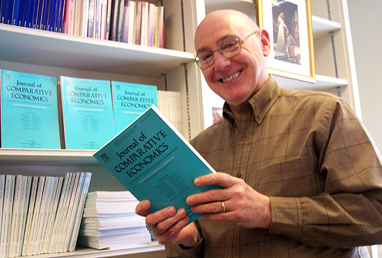
John Bonin, the Chester D. Hubbard Professor of Economics and Social Science, was the invited keynote speaker at the 5th annual CInSt Banking Workshop, hosted by the Center for International Studies at the National Research University Higher School of Economics in Moscow, Russia on Oct. 2. The theme of the conference was "Banking in Emerging Markets: Challenges and Opportunities." Bonin's talk was titled, "Did foreign banks 'cut and run' or stay committed to emerging Europe during the crises?" Bonin presented research he did together with Dana Louie '15. They examined the lending behavior of foreign banks during the global financial crisis and at the onset…
Hilary Barth, associate professor of psychology, is the co-author of an article titled "Spatial Estimation: A Non-Bayesian Alternative," published in Developmental Science, Volume 18, pages 853-862, in 2015. The paper is co-authored by Ellen Lesser ’15, as well as former Cognitive Development Labs coordinator Jessica Taggart and former postdoctoral fellow Emily Slusser. A large collection of estimation phenomena (for example, biases arising when adults or children estimate remembered locations of objects in bounded spaces) are commonly explained in terms of complex Bayesian models. Bayesian cognitive models seek to model human mental processes as approximations to ideal statistical inference. In this study, Barth and…
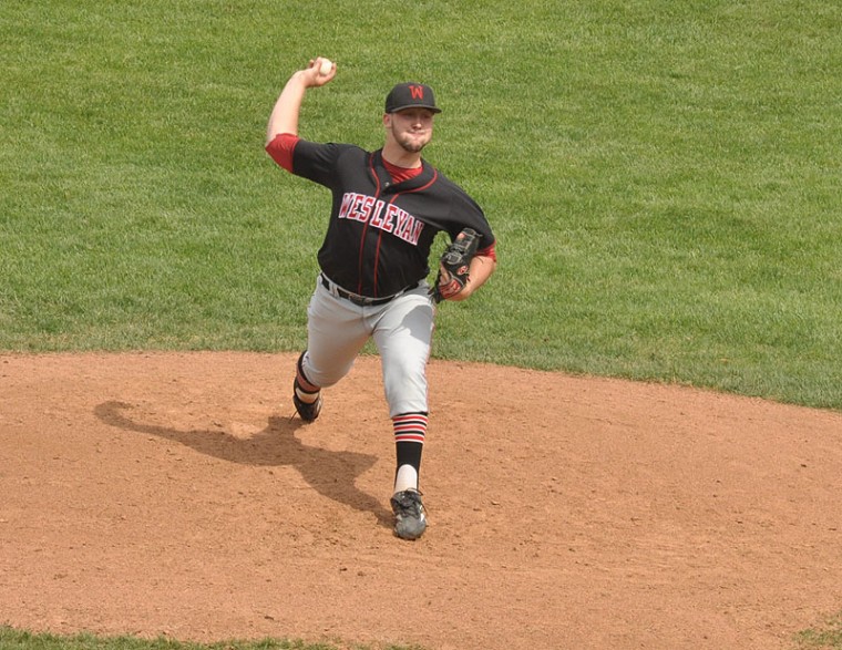
Three key players in Wesleyan baseball’s fantastic run over the last three years have signed professional baseball contracts this summer. Gavin Pittore ’16 signed a free-agent contract with the Los Angeles Dodgers; alumnus Nick Cooney ’15 signed a contract with the Fargo-Moorhead RedHawks in the independent American Association; and Donnie Cimino ’15 was drafted in the 37th round by the Chicago Cubs.
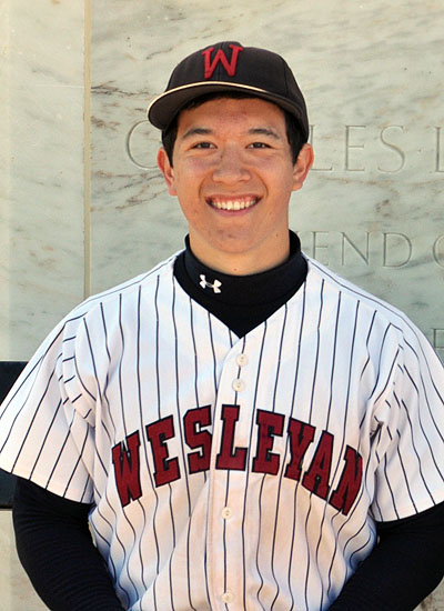
Baseball player Andrew Yin '15, who helped Wesleyan win two straight NESCAC titles, along with a perfect 12-0 conference record in 2015, was recently named a CoSIDA/Capital One First-Team Academic All-American for the second straight year. He is the only player among the 33 honorees on the three national teams in 2015 to repeat as a first-team choice. Yin also is the only player among those cited to be a three-time Academic All-American. In 2013, Yin, then a sophomore, made his first appearance as an Academic All-America third-team selection. Sophomores are rare on the squad as only one of the 33…
In this issue of News @ Wesleyan, we speak with Siri Carr ’15, who double majored in the College of Letters and Hispanic Literatures and Cultures. Carr’s thesis, Little Do We Know: Conceptualizing the “Little” in Children’s Literature, explores the concept of the “little” in children’s literature. The thesis was submitted for honors in the College of Letters.
#THISISWHY In this News @ Wesleyan story, we speak with Nicole Stanton from the Class of 2015. Stanton is a College of Letters and Hispanic literatures and cultures major. (more…)
#THISISWHY In this issue of News @ Wesleyan, we speak with Matan Koplin-Green from the Class of 2015. Q: Matan, what is your major and what was the title of your thesis? A: I’m a neuroscience and behavior major. I wrote my thesis on “Application of Alpha Neurofeedback in the Treatment of Anxiety Disorders.” Q: Let’s back up. How did your interest in neuroscience and behavior develop? A: I came to Wesleyan not knowing exactly what I wanted to study. I was interested in cognitive psychology and philosophy of mind, but also had a lifelong love of music. I took…